| The Department of Transportation has been lying and is deeply involved in covert military operations nationwide. “Highly reflective” markers of different variety began appearing on the backs of road signs across America with the explanation forwarded that the D.O.T. were “dating” road signs for sinage replacement and warranty purposes. “Free Indeed Research” has challenged this claim and has proven these road sign dating operations a “FAKE”! These markers are in reality, universal military directional code devices,*TACMARS*, verified by military personnel who have seen them being used by multi-national U.N. “PEACEKEEPERS”, to target vital sites, facilities and resources to be confiscated and used during a National Emergency. More startling information has been disclosed that the “fronts” of the road signs contain embedded codes as well and that our entire sign system has been cleverly altered and is shifting from a word based system to a “European” style complex of pictorials, images, color codes, and a variety of “ARROW” configurations!The following photos are samples of the codings deciphered by researchers through over 4 years of painstaking study of the markers and their configurations, target sites, and photo analysis. Our conclusive report of this phenomenon appears to be the final stages of a complex military plan called “OPERATION GARDEN PLOT” also known as, “UNITED STATES CIVIL DISTURBANCE PLAN 55-2”. This unclassified military plan involves the handling of civil disturbances through massive relocations of the populace via airlifts, mass transit, and rail to “SAFE ZONES” away from affected areas under MARTIAL LAW. As you view this website, may you be alerted to the dangers that may soon be unfolding. This kind of coding has been observed in many war-torn nations overseas and is linked to UN/NATO military.
“If my people, which are called by my name, shall humble themselves, and pray, and seek My face, and turn from their wicked ways, then will I hear from Heaven and will forgive their sin and heal their land.” (2Chronicles 7:14 KJV). |
|
|
“Red Cross” disaster relief sites target of “tacmark” sign codes. Note the patterns of the markers and their positionings. This is the key to understanding the code system being implemented. Those who believe that these markers are haphazardly slapped on the backs of signs have not studied these markers much indepth. We have spent over 4 years of intense study, and have hundreds of photographs at our disposal that show dynamic patterns and positionings, proving these tacmars have a decipherable meaning, that target vital sites, facilities and resources to be confiscated and used for military operations. We have coined this the “Quadrant Sign Code”. The markers operate as *pointers* or ARROWS, denoting direction, and creating *ARROW CONFIGURATIONS*. These symbols identify and point to a site or facility to be confiscated and used as a base of operation. These codes are created by positioning markers “quadrantly” on a directional field on the back of the sign, dividing the sign in half vertically. Markers positioned on the left side of the sign point *left*, while marker positioned on the right quadrant point *right*. Within this basic framework of directional markers is the *TACMARK* code system revealed. On this page you will view several TACMAR codes, each give coded information for military entering an unknown area, directing them to operational sites. We challenge you to go to your own city, town or village and checkout these tacmars on local signs. These configurations WILL be there! |
|
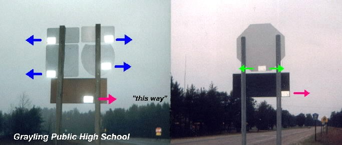
| MILITARY INSTALLATIONS marked for confiscation in Grayling, Michigan. The triad markers to the right are one of the most common tacmark configurations found in our area. Quadrantly placed markers are converted into “ARROWS” which point according to quadrant placement.The marker turned on “end” is an arrow “UP” code, signifying a site for pick-up helicopter airlifts. The two quadrantly placed markers point right into “Support Facility 2” a helicopter base with large heliports, aviation fuel depot, and a railroad passing through the facility. (There are some that argue that the marker turned on end is put that way only because of the narrow area of the sign would not allow it to be laid flat. This is somewhat true, but this argument doesn’t hold up well as you will view signs on this page where there is plenty of room on the back of the signs, yet the markers were purposely turned on end!)The facility sign also contains color codes and images “pointing at each other”. This is a common configuration of colors, and images with embedded codes for airlift sites here in Michigan.(Special note: Color codes *RED* and *BLUE* are dominate features on coded signs!) |
|
| “Grayling Army Airfield”, target of signcode markers. Incriminating evidence continues to surface that these sign codes are obviously for military confiscation. These air fields have frequent visits from “Partnership For Peace” member nations, Latvian, Estonian, and Lithuanian (Russian)troops who train with National Guard under U.N. supervision. North and South bound routes have these coded signs pointing in to the checkpoint gate. Markers in three’s are facility symbols noting an important site to confiscate. These triad markers are found at nearly every site targeted for confiscation. This falls under Emergency Executive Order #11003 which authorizes the seizure of all air transportation, airports, landing strips, both public, private, and commercial.Note the sign in each photo with no marker. Why? Are they dating only *some* of the signs or all the signs? That’s a good question! The truth here lies in the many photos we have taken which show these same patterns. Triad (3) markers are a special code signal noting an important site or facility. These markers also form geometric shapes such as the “ARROWHEAD” and a “BROKEN ARROW” which are used here as directionals!NOTE: We are not suggesting that these reflective markers are to be read from the air by military helicopters. Our study of the “TACMARS” reveal they will be read by personnel operating land based vehicles on the road way commissioned at setting up operational transfer (collection) points in the wake of a major disaster for civilian control, movement and relocation. Heliport sign codes reveal to these officers that airlift capabilities *exist* at a particular target site. |
|
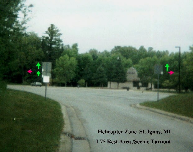
| “REST AREAS” off interstates and state highways, coded for helicopter pick-up/drop zone sites. This “TRUCK PARKING” area in St. Ignace, Michigan off Interstate-75 is coded for a military base of operation. Critics of our research have been put to rest when consistent patterns of marker placements appear at random sites.In the photo to the right, note “3” markers are turned on “END”. (Markers in threes are a confirmed “facility symbol” noting an important site to be confiscated and used. This familiar positioning is an arrow “UP” code. Markers pointing “up” are pick-up points, usually for helicopter or other airlift modes. (Note: There is lots of room on the back of these signs, yet *ALL THREE* markers are purposely turned on end!) “REST AREAS” provide an ideal setting for helicopter bases, with large parking lots, especially in the “TRUCK PARKING” lots. Executive Order #10999 grants seizure of all roads, highways, interstates, for emergency and military vehicles only.Note the markers positioned quadrantly, right side of the right sign, and left side of the left sign. This familiar pattern creates an “opposite pointing arrows” configuration which is a helicopter symbol used extensively at other heliports in Michigan. |
|
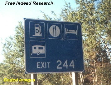
| “REST AREAS”, coded arrow configurations. As stated before, the “FRONTS” of many road signs are coded as well. The photo to the left is a familiar sign at nearly all REST AREAS on American interstates and state highways. Unkown to the public is that this “PARKING LOT DIRECTORY” sign contains a coded message for military operations. The coding is in the “ARROWS”. These clever arrow configurations show troops where the helicopter site is located. The “TRUCK and CAR w/ TRAILER” lots are large enough to easily handle any of the the largest heli-craft in operation today. Note the “3” arrows, a site identification code and consistent pattern at target sites. The “opposite pointing arrow” is a code signal, and bottom two arrows point to the “TRUCK and CAR w/TRAILER” parking area. The word “TRUCK” and “TRUCKS” are *code words* and are found at many sites coded for helicopters. |
|
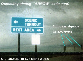
| MORE CODES AT “REST AREAS”. Here is an arrow configuration used quite extensively as a code symbol to mark military operational sites along our interstates and state highways. Entering this same St. Ignace “REST AREA” we are confronted with this “opposite-arrow” code giving information as to the location of *HELIPORTS* and *OBSERVATION TOWER*. We firmly believe these *REST AREAS* are especially layed-out and constructed with a secondary military use in mind, to initiate emergency, evacuation plans for*OPERATION GARDEN PLOT*.CLICK FOR GPS X’s>>>We have also discovered GPS satellite Xs painted on the pavements leading to the helicopter zone areas. The observation tower over-looks the entire ST. IGNACE and MACKINAW BRIDGE region. This important bridge linking the UPPER and LOWER Pennisula of our state, has a toll area coded with lots of TACMARS, making it a very strategic facility controling traffic flow across Lake Michigan and Lake Huron. |
|
| Michigan D.O.T. marker style phases / same code! Michigan has seen at least two phases in marker style changes over the past twenty years, and has undergone another one as of January 2002. To the left we observe a transition of markers from the original *clipped*, color coded marker(1980-89), to the pictorial image punch-dated markers,(1990-2000). Interviews with MDOT. supervisors revealed a wide variety of explanations (lies) why these markers are being placed on the back of road signs. Reasons given were: -“Those markers are for the snowplows, so they won’t hit the signs.” -“Well, we are testing paint to see how it withstands weathering.” -“We are testing adhesives, to see how long it takes them to fall off.” -“The markers are for chemical and hazardous haulers to follow.” The D.O.T. finally apologized for all the confusion and proclaimed in unison, “We are dating the road signs.” Oh really? This sign is dated twice! The “ORANGE” clipped marker, (color coded date 1989), does not match the date punched out on the other marker (1993). (Target site of these markers is a modular home sales yard. There are about 20 empty dwellings set-up next to a fresh water spring fed pond, and parking lots.) |
|
| European pictorial signs target this large office building. This European pictorial image sign denoting a “BIKE ROUTE” turns out to be *fake*. This large office building was once the administration building for “THE COMMONS”, a mental institution located off Division St. in Traverse City, Michigan. It is now owned by the Department of Transportation. This building was once a designated “CIVIL DEFENSE” fallout shelter during the 50’s, 60’s, and early 70’s. The “BIKE ROUTE” sign is fraudulent–there is NO “BIKE ROUTE” that travels by this building! The sign has a secondary meaning, that targets a facility to be confiscated and used by the military during a national emergency. Behind this facility is a parking area that is coded for a helicopter pick-up point and drop zone. Watch for these “bike route” signs! They are used to mark a site for a military base of operation. (SEE PHOTO BELOW) |
|
| “Handicapped Access” signs used to code helicopter site in parking lot behind the facility. Whenever you find “handicapped access” signs and symbols and “YIELD” signs, you will also find an important site to be confiscated by the military. Again, these signs are *European* in origin.When foreign sinage began to be injected into our own sign system in the 1960’s the American people were told by the Department of Transportation, these signs were needful because of all of the *European* tourist entering our country, that we have to make them feel more at home while visiting our country! This fabricated *LIE* wrapped in an excuse is now exposed! In our research, these foreign signs are a major component in a scheme to set-up our nation, not for foreign *tourists*, but for an invasion of multinational foreign troops! This was the real reason for their arrival in America, and it is continuing covertly and unabated. Actually, American road signs are becoming more and more confusing to understand as they shift to “wordless pictorials” and strange *stackings* of signage to accomodate the hidden codes for military operations.Arrows pointing “UP” are a confirmed code symbol that identifys an important site and has been a regular feature at helicopter pick-up and drop zones. |
|
| Strange sign *stackings* and European signage at Public Schools. Public schools are designated Red Cross disaster relief facilities, therefore it is not strange to find coded military signs at these sites. This elementary school, near Traverse City, Michigan, is a good example of this coding and the strange stacking of wordless road signs. Those of you who believe there is no basis to our reports of military sign codes better take a hard look at the photo to the right.After investigating these signs we find it very odd that an advertisement for “GOLFING” be stacked atop of a warning sign for school children! Something here is grossly out of place. Even more mysterious is that we have searched far and wide for the golf course, or driving range, or whatever this pictorial “golfing” sinage is alluding to, and found nothing! This kind of confusing signage is quite common with coded signs. Note the familiar coded “arrow-up” symbol which is a common sign code at sites that are slated for military confiscation denoting AIRLIFT/DROP ZONES for helicopters, and other modes of transfer. Also note the 3 pictorial human “images”. Three, is a facility code we have often reported at target sites, especially at this public school where “people” will be housed, sorted, and transported for relocation to other facilities during “MARTIAL LAW”. |
|
| “GOALS 2000” / PREPARING OF PUBLIC SCHOOLS. The past Administration made a mad dash to prepare the public schools for the year 2000, by including important upgrades in internet technology, fiber-optics, swipecard/consoles and laser scanning equipment. (Thumb scanning devices are now being used in some states for the public school hot-lunch programs, where biometric ID scanners deduct from *student bank accounts* to pay for their lunches! If this does not alarm you, you had better get educated! Your privacy and freedoms are on the line here!) Prior to the millennium, “GOALS 2000” put into law these features to be installed in every public school in the U.S. “for the children”, as we have heard so often just before more of our freedoms were about to be trampled upon.While disguised as one of America’s most grandeous strides in modern education, computer technology has converted the public schools into centralized databases with personal information on every citizen within the district, primarily to *track* every child whether they attend public schools or not. All records are stored and claim to be confidential, though with a simple code one can access the most personal files and information on any student and their families.It is our contention that the public schools are being groomed and prepared to handle a National Crisis and will become *processing centers* of control. (Aren’t they already?) As you read through the information on the sign codes on our website, you will observe that the public schools are not only marked as facilities for refuge as safe zones, but centers to register the populace for the purpose movement and relocation, during a National Emergency using computer technology. IMPORTANT NOTE (The emergence of cellular communications towers in very close proximity of public schools is a well documented fact, with some erected on the school property and even in playground areas!) |
|
| Coded “images” with a secondary meaning for military operations. International/European images are clever code devices on U.S. roads and highways to signal operational sites prepared by FEMAfor the military. We believe these military consist of multi-national forces (“peacekeepers”)laced with foreign troops who are well familiar with these foreign signs and symbology injected into our sign system. This makes these signs and symbols very strategic in value.We must reiterate, that we believe these markers and sinage are to *pinpoint* important sites and facilities prepared for a specific, pre-arranged operation, planned over many years. It is a “civil disturbance” plan using many of our own public facilities and technology, that will deal with hundreds of thousands of frightened, confused citizens, victims of a major catastrophe and the carnage left behind in it’s aftermath. Our findings and research fit hand-in-glove with the “Emergency Executive Orders” to be implemented for such a scenario. It is time our critics begin putting this phenomenon into this perspective and start thinking beyond the end of their own noses and ego. The coding is there and has been verified by reputable, decorated and honorable servicemen we have interviewed, and we believe their reports. |
|
Skip to content
(The West Virginia Blogger)


