One of the most startling discoveries while deciphering the TACMAR codes on the back of road signs was that the *fronts* of the signs have embedded codes as well! This was first realized when we deciphered that the TACMARS are actually directional or “ARROWS” that point according to *where* the markers was positioned or *tilted* on the back of the signs. As the different arrow patterns were deciphered, we began seeing a correlation to actual arrow patterns and configurations found on the fronts of signs.
As you view the photos on this page, you will begin to see the correlation of markers on the back of signs, and arrow configurations on the front of signs. These are coded messages for the military in identifying sites, and facilities pre-selected as a*staging areas* during a national emergency.
*OUR ROAD SIGNS ARE BEING ALTERED FOR MILITARY OPERATIONS.*
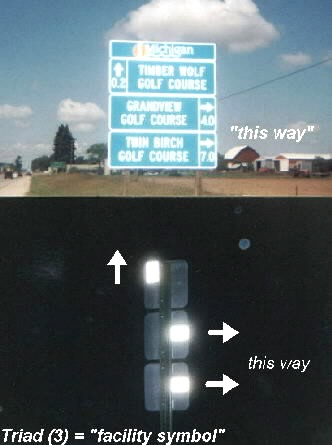
| Matching *ARROW* codes, front and rear of signs. Here is further proof of the connection of TACMARK codes on the back of road signs, and ARROWS cleverly coded on the fronts of signs.Again, note the triad (3) markers and arrows, which is a confirmed facility symbol, targeting an important site for confiscation. Arrows *UP* denote a pick-up point of some kind, usually airlift/drop zone site. This is especially true of the “GOLF COURSES” advertised on the “blue” tourist attraction sign in the top photo. All three of the advertised golf courses have been marked by sign codes. These sites are frequent landing zones for medi-vac helicopters and are designated emergency airlift sites. Many highway, accident victims have been airlifted from golf course greens because of the well landscaped and manicured fairways.*WATCH FOR THESE BLUE “TOURIST ATTRACTION” SIGNS. THESE ARE NEW, AND TARGET FACILITIES OR ROUTES SLATED FOR MILITARY CONFISCATION.* |
|
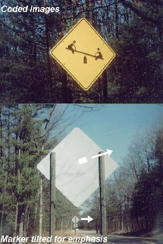
| *Recreational Parks*, the target of International/European pictorial signs. “Garden Plot” evacuation site. I direct your attention to the top photo. Note the *ARROW UP* between the two images pointing *at* each other. This is a very familiar sign code array! Like the markers, images on signs, logos, billboards and other pictorials on the roadways are positioned strategically to form coded configurations. Also note the “tilted” marker in the upper-right quadrant on the back of this sign. Tilted markers are done for emphasis, especially when the targeted site is in view, as is the case with this “PARK” which is across the roadway from this sign. Also note the “stacked” sign further back on the roadway, with the marker pointing in the same direction.This recreational park has been constructed for a secondary use as a base of operation for “OPERATION GARDEN PLOT”. There is an incriminating 9ft. high fence, completely enclosing new *tennis courts*, (detention area), *baseball park*, (heliport) and *high intensity lights*. (This park is closed after dark!) CLICK ON PHOTO>>> This kind of scenario is repeated throughout Michigan. New parks are being constructed in small rural areas with these incriminating features. It is our conviction that these are FEMA/MILITARY base of operation, evacuation sites in the event of a chemical/biologica/nuclear attack, servicing these rural pockets of the populace. |
|
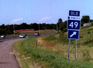
| *STACKED* COLOR CODED SIGNS THAT SAY ONE THING, BUT POINT TO SOMETHING ELSE. The “3” signs in this photo, taken in Minnesota, have been placed on the roadway with a clever, secondary meaning. While information on the signs describe an off-ramp to “OLD 49”, a close inspection shows the *arrow* pointing “up” at a large, fenced area with *tops-in* barbed wire in the high ground. I have included this important photo to show the clever use of deception that is being utilized to cover up what is really going on with our road signs. This is the kind of thing to look for: signs and arrows that indicate one thing, but in actuality they are codes pointing to a target site to be confiscated and used for military purposes. Note the color code “BLUE”. This color code has been found at the majority of detention sites in Michigan and appears to follow with the same coding in Minnesota. TACMARS are not needed on these signs because the codes are on the front. |
|
| Campgrounds and Parks targeted with signcodes as relocation facilities. Watch for these phony snowmobile routes, (bike routes)ect. These are *DISASTER CORRIDORS* that connect to the targeted sites FEMA has setup for “OPERATION GARDEN PLOT”. Common sense tells us that this photo shows a major “blooper” by those coding this campground and park. This campground and park are closed in the winter! Why would they direct snowmobiles to a closed park and campground? On the other hand, what snowmobilers would be driving their snowmobile on this paved roadway into this park in the summer when this park and campground are in season?! This is another classic example of the incriminating and bogus signs that are being erected by D.O.T. and Road Commission who are directing these operations for the military) *CLICK ON RIGHT PHOTO!>>>Here again we see the all familiar *ARROW UP* symbol with two European signs. Note also the “Speed Limit” sign in the background targeting *high fenced in* tennis courts (DETENTION AREA). |


